
PLANNING EFFORTS
PLANNING EFFORTS
Over many decades, public agencies across the Phoenix metro area have spearheaded a variety of planning efforts along the Salt and Gila River corridor, both in terms of organizational development and urban planning. From the Rio Salado Development District and the Rio Salado Foundation to the early aspirations of the El Rio Watercourse Master Plan (2006) and the Rio Salado Beyond the Banks Area Plan (2003), the Rio Reimagined study area (1-2 miles above the riverbanks) has been an intermittent focus for planners and leaders.
Read on to learn more about current planning activity within the corridor, including the beginning of a vision planning process for Rio Reimagined, the regional revitalization initiative.
URBAN PLANNING
Rio Reimagined Regional Vision Planning Process
(Arizona State University, Maricopa Association of Governments, Greater Phoenix Leadership)
After several years as a 'start-up' initiative, Rio Reimagined is preparing for a multi-year regional vision planning process. Based on the results of an intentional scoping effort that was completed in December 2025, a regional vision plan for the river corridor would provide a strategic framework that defines a shared, overarching direction for the future of the urban Salt and Gila River corridor. Such a plan will build upon a foundation of existing plans, projects, and community engagement efforts aligning past and ongoing work while identifying key gaps and connections to guide coordinated action at a regional scale.
This process is just beginning. Click here for more information and opportunities to get involved in visioning your Rio Reimagined.
MAG Rio Reimagined Active Transportation Study: Public Comment Period Open October 6 – November 4
(Maricopa Association of Governments)
Provide your input on the draft 90-mile trail alignment along the Salt and Gila rivers. Visit MAGRioActive.com to explore the interactive draft study and share comments through the built-in survey, or email kbork@azmag.gov. Comments are due November 4.
The draft alignment reflects 20 months of work and input from hundreds of stakeholders, developed in coordination with six municipalities, two Native nations, unincorporated Maricopa County, and ASU Rio Reimagined.
Funded by the Maricopa Association of Governments (MAG) and shaped through collaboration with communities, the study is about more than creating trails. It identifies ways to improve walking and biking connections along the river corridor, link neighboring communities, and funding strategies while strengthening connection between people, communities, and the Salt and Gila rivers. Together, these proposed investments are meant to expand transportation choices, support local economies, improve health, and celebrate the region’s unique natural and cultural heritage.
RIO PHX: Phoenix approves the Rio Salado District Policy Plan
On October 21, 2026, Phoenix City Council voted to approve the Rio Salado District Policy Plan and accompanying General Plan Land Use Map amendment, to guide future land use and development decisions beyond the riverbanks in the Rio Salado District. This plan provides a new framework to strengthen the connection between people, nature, and the built environment and presents a renewed vision for the area with four key goals or “big ideas” that include:
- Establish a vibrant mix of uses
- Connect residents and visitors to the Rio Salado
- Improve community well-being and quality of life
- Establish a hub for eco-tourism and green infrastructure.
The area is bounded by Interstate 17 to the north, Broadway Road to the south, 32nd Street to the east, and 19th Avenue to the west.
The policy plan also referenced the RIO PHX Design Guidelines as a tool that will further inform development along the 20-mile-long Rio Salado corridor in Phoenix. These guidelines are intended to inspire developers, property owners, architects, and landscape designers to create a welcoming, contextually appropriate sense of place within the corridor.
To review the latest plan documents and to stay informed on next steps, please visit https://www.phoenix.gov/pdd/riophx.
For more information, please contact Enrique Bojórquez Gaxiola, Planner III, at enrique.bojorquez-gaxiola@phoenix.gov or 602-262-6949.

Click Here for a simplified illustration that describes the differences in scale and focus of these three planning initiatives.
ORGANIZATIONAL DEVELOPMENT
Rio Reimagined Social Impact Organization (501(c)3)
(Greater Phoenix Leadership)
Most successful regional revitalization initiatives involve a dedicated non-profit organization that supports the individual and collective vision of its community partners. For Rio Reimagined, a new social impact organization is in formation by Greater Phoenix Leadership (GPL), an organization of leading CEOs aligning leadership and resources at the intersection of the business, education, philanthropy and public policy sectors to improve economic vitality and quality of life.
For more information, contact Max Hartgraves at max@gplinc.org.
URBAN PLANNING

Rio Reimagined Regional Vision Planning Process
(Arizona State University, Maricopa Association of Governments, Greater Phoenix Leadership)
After several years as a 'start-up' initiative, Rio Reimagined is preparing for a multi-year regional vision planning process. Based on the results of an intentional scoping effort that was completed in December 2025, a regional vision plan for the river corridor would provide a strategic framework that defines a shared, overarching direction for the future of the urban Salt and Gila River corridor. Such a plan will build upon a foundation of existing plans, projects, and community engagement efforts aligning past and ongoing work while identifying key gaps and connections to guide coordinated action at a regional scale.
This process is just beginning. Click here for more information and opportunities to get involved in visioning your Rio Reimagined.

MAG Rio Reimagined Active Transportation Study: Public Comment Period Open October 6 – November 4
MAG Rio Reimagined Active Transportation Study: Public Comment Period Open October 6 – November 4
(Maricopa Association of Governments)
Provide your input on the draft 90-mile trail alignment along the Salt and Gila rivers. Visit MAGRioActive.com to explore the interactive draft study and share comments through the built-in survey, or email kbork@azmag.gov. Comments are due November 4.
The draft alignment reflects 20 months of work and input from hundreds of stakeholders, developed in coordination with six municipalities, two Native nations, unincorporated Maricopa County, and ASU Rio Reimagined.
Funded by the Maricopa Association of Governments (MAG) and shaped through collaboration with communities, the study is about more than creating trails. It identifies ways to improve walking and biking connections along the river corridor, link neighboring communities, and funding strategies while strengthening connection between people, communities, and the Salt and Gila rivers. Together, these proposed investments are meant to expand transportation choices, support local economies, improve health, and celebrate the region’s unique natural and cultural heritage.
RIO PHX: Phoenix approves the Rio Salado District Policy Plan
RIO PHX: Phoenix approves the Rio Salado District Policy Plan
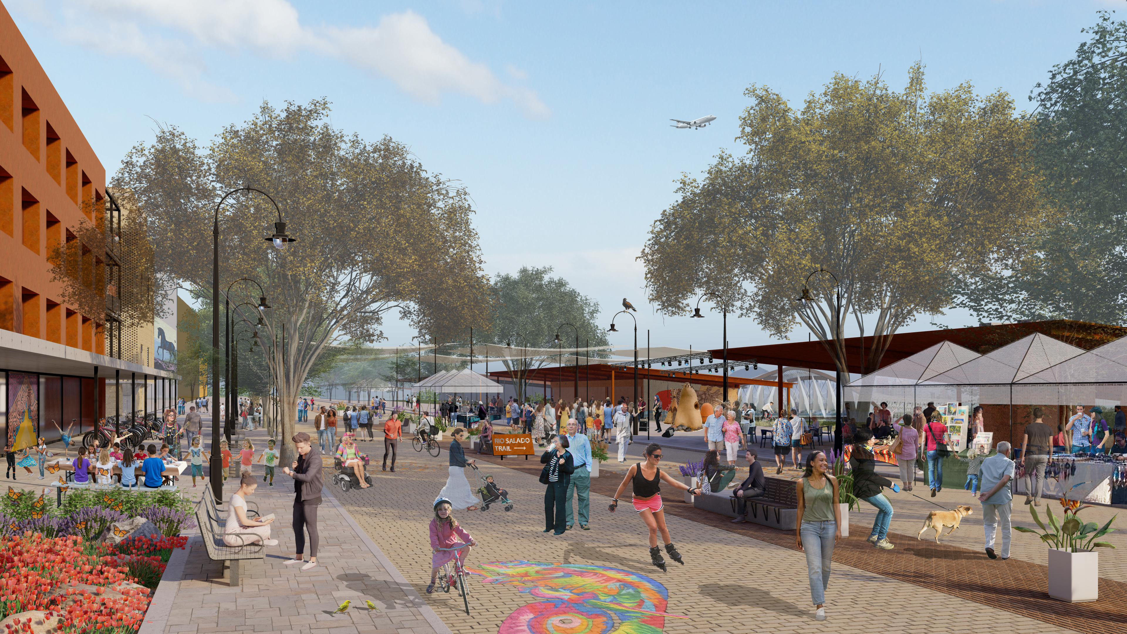
On October 21, 2026, Phoenix City Council voted to approve the Rio Salado District Policy Plan and accompanying General Plan Land Use Map amendment, to guide future land use and development decisions beyond the riverbanks in the Rio Salado District. This plan provides a new framework to strengthen the connection between people, nature, and the built environment and presents a renewed vision for the area with four key goals or “big ideas” that include:
- Establish a vibrant mix of uses
- Connect residents and visitors to the Rio Salado
- Improve community well-being and quality of life
- Establish a hub for eco-tourism and green infrastructure.
The area is bounded by Interstate 17 to the north, Broadway Road to the south, 32nd Street to the east, and 19th Avenue to the west.
The policy plan also referenced the RIO PHX Design Guidelines as a tool that will further inform development along the 20-mile-long Rio Salado corridor in Phoenix. These guidelines are intended to inspire developers, property owners, architects, and landscape designers to create a welcoming, contextually appropriate sense of place within the corridor.
To review the latest plan documents and to stay informed on next steps, please visit https://www.phoenix.gov/pdd/riophx.
For more information, please contact Enrique Bojórquez Gaxiola, Planner III, at enrique.bojorquez-gaxiola@phoenix.gov or 602-262-6949.
CLICK HERE for a simplified illustration that describes the differences in scale and focus of these three planning initiatives.
ORGANIZATIONAL DEVELOPMENT

Rio Reimagined Social Impact Organization (501(c)3)
Rio Reimagined Social Impact Organization (501(c)3)
(Greater Phoenix Leadership)
Most successful regional revitalization initiatives involve a dedicated non-profit organization that supports the individual and collective vision of its community partners. For Rio Reimagined, a new social impact organization is in formation by Greater Phoenix Leadership (GPL), an organization of leading CEOs aligning leadership and resources at the intersection of the business, education, philanthropy and public policy sectors to improve economic vitality and quality of life.
For more information, contact Max Hartgraves at max@gplinc.org.
URBAN PLANNING
Rio Reimagined Vision Planning Process
(Arizona State University, Maricopa Association of Governments, Greater Phoenix Leadership)
After several years as a 'start-up' initiative, Rio Reimagined is preparing for a multi-year regional vision planning process. Based on the results of an intentional scoping effort that was completed in December 2025, a regional vision plan for the river corridor would provide a strategic framework that defines a shared, overarching direction for the future of the urban Salt and Gila River corridor. Such a plan will build upon a foundation of existing plans, projects, and community engagement efforts aligning past and ongoing work while identifying key gaps and connections to guide coordinated action at a regional scale.
This process is just beginning. Click here for more information and opportunities to get involved in visioning your Rio Reimagined.
MAG Rio Reimagined Active Transportation Study: Public Comment Period Open October 6 – November 4
(Maricopa Association of Governments)
Provide your input on the draft 90-mile trail alignment along the Salt and Gila rivers. Visit MAGRioActive.com to explore the interactive draft study and share comments through the built-in survey, or email kbork@azmag.gov. Comments are due November 4.
The draft alignment reflects 20 months of work and input from hundreds of stakeholders, developed in coordination with six municipalities, two Native nations, unincorporated Maricopa County, and ASU Rio Reimagined.
Funded by the Maricopa Association of Governments (MAG) and shaped through collaboration with communities, the study is about more than creating trails. It identifies ways to improve walking and biking connections along the river corridor, link neighboring communities, and funding strategies while strengthening connection between people, communities, and the Salt and Gila rivers. Together, these proposed investments are meant to expand transportation choices, support local economies, improve health, and celebrate the region’s unique natural and cultural heritage.
RIO PHX: Phoenix approves the Rio Salado District Policy Plan
On October 21, 2026, Phoenix City Council voted to approve the Rio Salado District Policy Plan and accompanying General Plan Land Use Map amendment, to guide future land use and development decisions beyond the riverbanks in the Rio Salado District. This plan provides a new framework to strengthen the connection between people, nature, and the built environment and presents a renewed vision for the area with four key goals or “big ideas” that include:
- Establish a vibrant mix of uses
- Connect residents and visitors to the Rio Salado
- Improve community well-being and quality of life
- Establish a hub for eco-tourism and green infrastructure.
The area is bounded by Interstate 17 to the north, Broadway Road to the south, 32nd Street to the east, and 19th Avenue to the west.
The policy plan also referenced the RIO PHX Design Guidelines as a tool that will further inform development along the 20-mile-long Rio Salado corridor in Phoenix. These guidelines are intended to inspire developers, property owners, architects, and landscape designers to create a welcoming, contextually appropriate sense of place within the corridor.
To review the latest plan documents and to stay informed on next steps, please visit phoenix.gov/pdd/riophx.
For more information, please contact Enrique Bojórquez Gaxiola, Planner III, at enrique.bojorquez-gaxiola@phoenix.gov or 602-262-6949.
CLICK HERE for a simplified illustration that describes the differences in scale and focus of these three planning initiatives.
ORGANIZATIONAL DEVELOPMENT
Rio Reimagined Social Impact Organization (501(c)3)
(Greater Phoenix Leadership)
Most successful regional revitalization initiatives involve a dedicated non-profit organization that supports the individual and collective vision of its community partners. For Rio Reimagined, a new social impact organization is in formation by Greater Phoenix Leadership (GPL), an organization of leading CEOs aligning leadership and resources at the intersection of the business, education, philanthropy and public policy sectors to improve economic vitality and quality of life.
For more information, contact Max Hartgraves.
ASU Students Study Regional Governance Models
A team of ASU undergraduate seniors in the School of Public Affairs recently conducted a review of several governance models of large regional infrastructure initiatives across the country. The academic exercise provided an analysis of the organizational structure and governance of multijurisdictional planning organizations, including legislative authority, funding and decision-making. The work will inform Rio Reimagined communities as they evaluate long-term function and implementation of regional projects. For more information on the students’ governance review, please email info@rioreimagined.com.
For more information about ASU’s School of Public Affairs and the new ASU Center for Local Government Education click link below.
PLANNING TOOLS
There are dozens of planning tools available to Rio Reimagined partners working on these and other planning efforts. Here are a few examples of local and national resources that relate to current and future work in the river corridor.

City of Phoenix Green Stormwater Infrastructure handbook
City of Phoenix Green Stormwater Infrastructure handbook
Green Stormwater Infrastructure means Infrastructure constructed with a range of measures that use plant or soil systems, other permeable surfaces or substrates, stormwater harvest and reuse, or landscaping to store, infiltrate, or evapotranspirate stormwater and reduce flows to the public storm drain system or to surface waters.

Healthy Streams and Rivers Messaging Handbook
Healthy Streams and Rivers Messaging Handbook
A new handbook offers plain-language tools to communicate with decision-makers about the importance of protecting and restoring healthy stream and river systems in the West. This resource, created by the Metropolitan Group, supports diverse partners in a common effort to strengthen the case for investment in healthy stream and rivers systems.

Heat Vulnerability Map and Cool Solutions Webtool
Heat Vulnerability Map and Cool Solutions Webtool
The Heat Vulnerability Map and Cool Solutions Webtool is a research project transformed into a public good everyone can access.
The interactive heat map explores which parts of the city are highly exposed to heat and who is most vulnerable in these areas. It helps to prioritize investments in cooling infrastructure in high heat vulnerability areas.
PLANNING TOOLS
There are dozens of planning tools available to Rio Reimagined partners working on these and other planning efforts. Here are a few examples of local and national resources that relate to current and future work in the river corridor.
City of Phoenix Green Stormwater Infrastructure handbook
Green Stormwater Infrastructure means Infrastructure constructed with a range of measures that use plant or soil systems, other permeable surfaces or substrates, stormwater harvest and reuse, or landscaping to store, infiltrate, or evapotranspirate stormwater and reduce flows to the public storm drain system or to surface waters.
Healthy Streams and Rivers Messaging Handbook
Heat Vulnerability Map and Cool Solutions Webtool
The Heat Vulnerability Map and Cool Solutions Webtool is a research project transformed into a public good everyone can access.
The interactive heat map explores which parts of the city are highly exposed to heat and who is most vulnerable in these areas. It helps to prioritize investments in cooling infrastructure in high heat vulnerability areas.
PLANNING TOOLS
There are dozens of planning tools available to Rio Reimagined partners working on these and other planning efforts. Here are a few examples of local and national resources that relate to current and future work in the river corridor.
City of Phoenix Green Stormwater Infrastructure handbook
Green Stormwater Infrastructure means Infrastructure constructed with a range of measures that use plant or soil systems, other permeable surfaces or substrates, stormwater harvest and reuse, or landscaping to store, infiltrate, or evapotranspirate stormwater and reduce flows to the public storm drain system or to surface waters.
Healthy Streams and Rivers Messaging Handbook
A new handbook offers plain-language tools to communicate with decision-makers about the importance of protecting and restoring healthy stream and river systems in the West. This resource, created by the Metropolitan Group, supports diverse partners in a common effort to strengthen the case for investment in healthy stream and rivers systems.

Heat Vulnerability Map and Cool Solutions Webtool
The Heat Vulnerability Map and Cool Solutions Webtool is a research project transformed into a public good everyone can access.
The interactive heat map explores which parts of the city are highly exposed to heat and who is most vulnerable in these areas. It helps to prioritize investments in cooling infrastructure in high heat vulnerability areas.
ASU Urban Planning Students Create Rio Reimagined Story Map
In Spring 2025, a passionate and energized team of graduate students from Arizona State University’s Master of Urban and Environmental Planning (MUEP) program participated in a Planning Workshop dedicated to the Rio Reimagined (RIO) Rivershed Asset Mapping project. Working with members of the Rio Reimagined partnership, the student team developed a draft asset map to support regional planning efforts along the Salt and Gila River corridor. Spanning 55 miles and encompassing six municipalities, two Native Nations, and Maricopa County, this urban geography project bridged academic theory with real-world application in GIS, stakeholder engagement, and sustainable planning.
Stay Informed
Sign up to receive news, updates, and Rio Reimagined Partnership meeting invites to keep informed about the initiative.
Stay Connected
Sign up to receive news, updates, and Rio Partnership meeting invites to keep informed about the initiative.