FEATURED PROJECTS
FEATURED PROJECTS
Over many decades, communities along the river corridor have invested in discrete projects that focus on river health, water treatment and recharge, recreation, educational programming and economic development. The essence of Rio Reimagined relates to a regional effort to connect and enhance this urban greenway of existing and future projects, linking nodes of recreational, environmental, economic, and social services together across cities and nations.
Visit the links below to learn more about some Rio Reimagined projects in progress along the river corridor.
ECONOMIC DEVELOPMENT:
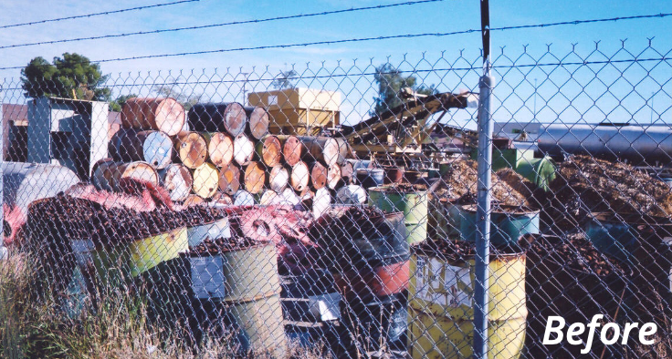
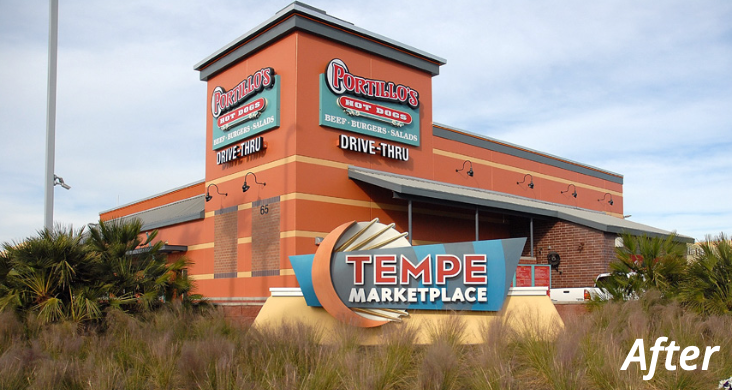
City of Phoenix Brownfields Revolving Loan Funding Available
City of Phoenix Brownfields Revolving Loan Funding Available
From 20220-2025, the cities of Phoenix, Tempe, and Avondale joined forces to secure a significant 2020 EPA grant to evaluate and clean-up brownfields (previously polluted or abandoned sites) along the Salt River. The Arizona Department of Environmental Quality (ADEQ) and private sector experts partnered in the effort to leverage regional cooperation into multi-year funding that supported inventories, technical assessment for priority sites, to incentivize revitalization.
The City of Phoenix also received an EPA Revolving Loan Fund grant to provide funding for clean-up and reuse of strategic sites. This new financing tool provides loans/grants for soil and groundwater cleanup at environmentally contaminated properties, or for asbestos abatement in buildings. Abandoned, inactive, or underutilized properties may qualify, including former industrial sites, gas stations and dry cleaning establishments. Loans to private businesses are available at a low interest rate of 3%. For nonprofits, grants are available.
For more information, go to www.phoenix.gov/oep/brownfields or you can contact Emma Green at brownfields@phoenix.gov.
ECONOMIC DEVELOPMENT:
Rio Reimagined Brownfields Coalition Grant
Rio Reimagined Brownfields Coalition Grant
From 20220-2025, the cities of Phoenix, Tempe, and Avondale joined forces to secure a significant 2020 EPA grant to evaluate and clean-up brownfields (previously polluted or abandoned sites) along the Salt River. The Arizona Department of Environmental Quality (ADEQ) and private sector experts partnered in the effort to leverage regional cooperation into multi-year funding that supported inventories, technical assessment for priority sites, to incentivize revitalization.
The City of Phoenix also received an EPA Revolving Loan Fund grant to provide funding for clean-up and reuse of strategic sites. This new financing tool provides loans/grants for soil and groundwater cleanup at environmentally contaminated properties, or for asbestos abatement in buildings. Abandoned, inactive, or underutilized properties may qualify, including former industrial sites, gas stations and dry cleaning establishments. Loans to private businesses are available at a low interest rate of 3%. For nonprofits, grants are available.
For more information, go to www.phoenix.gov/oep/brownfields or you can contact Emma Green at brownfields@phoenix.gov.
RECREATION:
Phoenix Parks and Recreation Transforms the Rio Salado Through Community Collaboration
Phoenix Parks and Recreation Transforms the Rio Salado Through Community Collaboration
The City of Phoenix Parks and Recreation Department has spearheaded the creation of concept designs for the transformation of a prime, City-owned one-acre vacant parcel along the southern bank of the Rio Salado, located near the new Central Avenue light rail station at Pioneer Street. This site offers a unique opportunity to collaborate with the community in developing a landscaped public gathering space that enhances connectivity to the Rio Salado. The Transformation Site was established with the support of community leaders from the Protectors of the Salt River, who led resident canvassing and community engagement to help shape the vision for this space.
Over the past two years, Parks and Recreation organized community design workshops focused on planting, education, and design. The community vision is to transform the site by adding shade, seating, trees, greenery, and diverse programming, all while honoring and celebrating the South Mountain and Indigenous communities.
The City and partners are currently in discussion on funding necessary to transform the pocket park, enhance the quality of life for nearby neighborhoods and create new public space that will allow Phoenix residents to safely access and engage with the Rio Salado as a vibrant cultural and environmental destination.
Learn more about the City of Phoenix’s Rio Salado Habitat Restoration Area.

“The legacy of the Rio Salado has shaped our city in countless ways. I’m thrilled to create new opportunities for our residents to connect with the river and to revitalize it into a thriving region where Phoenix families can enjoy everything it has to offer,”
Kate Gallego – Mayor of Phoenix, Arizona
“The transformation of this site represents a significant step in enhancing both the environment and the community’s connection to the Rio Salado. By working closely with residents, we are creating a space that not only improves the landscape but also fosters a deeper sense of place and cultural connection,”
Cynthia Aguilar – Parks and Recreation Department Director, City of Phoenix, Arizona
Estrella Mountain Regional Park (EMRP)
Activities, events and resources abound at this jewel of a regional park along the Gila River in the west reach of Rio Reimagined. EMRP is part of Maricopa County’s Parks Vision 2030 Plan, which identifies the traits of a high-quality regional system of parks, open spaces, and trails, and sets a goal of protection and restoration of river corridors for public recreation and ecosystem services. From 2022-2023, the park was the site for a new pollinator garden funded by a Rio Reimagined grant from the Arizona Department of Forestry and Fire Management. The project involved numerous national and local non-profit and private sector partners, resulting in the removal of acres of invasive plants and the installation of hundreds of pollinator shrubs and trees.
See also:
Maricopa County’s Natural Resource Plan 2024
A County guide to managing natural resources in their parks.


“The legacy of the Rio Salado has shaped our city in countless ways. I’m thrilled to create new opportunities for our residents to connect with the river and to revitalize it into a thriving region where Phoenix families can enjoy everything it has to offer,”
Kate Gallego – Mayor of Phoenix, Arizona
“The transformation of this site represents a significant step in enhancing both the environment and the community’s connection to the Rio Salado. By working closely with residents, we are creating a space that not only improves the landscape but also fosters a deeper sense of place and cultural connection,”
Cynthia Aguilar – Parks and Recreation Department Director, City of Phoenix, Arizona
RECREATION:
Phoenix Parks and Recreation Transforms the Rio Salado Through Community Collaboration
Phoenix Parks and Recreation Transforms the Rio Salado Through Community Collaboration
The City of Phoenix Parks and Recreation Department has spearheaded the creation of concept designs for the transformation of a prime, City-owned one-acre vacant parcel along the southern bank of the Rio Salado, located near the new Central Avenue light rail station at Pioneer Street. This site offers a unique opportunity to collaborate with the community in developing a landscaped public gathering space that enhances connectivity to the Rio Salado. The Transformation Site was established with the support of community leaders from the Protectors of the Salt River, who led resident canvassing and community engagement to help shape the vision for this space.
Over the past two years, Parks and Recreation organized community design workshops focused on planting, education, and design. The community vision is to transform the site by adding shade, seating, trees, greenery, and diverse programming, all while honoring and celebrating the South Mountain and Indigenous communities.
The City and partners are currently in discussion on funding necessary to transform the pocket park, enhance the quality of life for nearby neighborhoods and create new public space that will allow Phoenix residents to safely access and engage with the Rio Salado as a vibrant cultural and environmental destination.
Learn more about the City of Phoenix’s Rio Salado Habitat Restoration Area.
Estrella Mountain Regional Park (EMRP)
Activities, events and resources abound at this jewel of a regional park along the Gila River in the west reach of Rio Reimagined. EMRP is part of Maricopa County’s Parks Vision 2030 Plan, which identifies the traits of a high-quality regional system of parks, open spaces, and trails, and sets a goal of protection and restoration of river corridors for public recreation and ecosystem services. From 2022-2023, the park was the site for a new pollinator garden funded by a Rio Reimagined grant from the Arizona Department of Forestry and Fire Management. The project involved numerous national and local non-profit and private sector partners, resulting in the removal of acres of invasive plants and the installation of hundreds of pollinator shrubs and trees.
See also:
Maricopa County’s Natural Resource Plan 2024
A County guide to managing natural resources in their parks.
ENVIRONMENTAL RESTORATION:
Replacing Invasive Plants with Native Species
Replacing Invasive Plants with Native Species
Over time, changes in water supply, land use and climate have created conditions that threaten the health of the urban riverine ecosystem of the Salt and Gila River. Many public, non-profit and private sector partners are working together to address this massive challenge with project work in the western reach of Rio Reimagined, led by the coordinated efforts of the Lower Gila River Collaborative and the State Department of Forestry and Fire Management.
INFRASTRUCTURE:
City of Phoenix 3rd Street Bridge
City of Phoenix 3rd Street Bridge
The City of Phoenix is currently in the design stage for a project that will transform access to the Salt River and the neighborhoods north and south, through the construction of a bike/pedestrian bridge at 3rd Street. This project, funded through a $25M U.S. Department of Transportation ‘Rebuilding American Infrastructure with Sustainability and Equity’ (RAISE) Grant, will be the city’s first and only dedicated bicycle and pedestrian bridge across the Rio Salado (Salt River).
The riverbank trails along the southern bank will also be improved through the addition of low-emitting solar pedestrian-scale lighting and pathway amenities between Central Avenue and 40th Street.

State Route 30, 97th Avenue to Loop 202 project
The Arizona Department of Transportation (ADOT), Federal Highway Administration (FHWA) and the Maricopa Association of Governments (MAG), are designing and constructing State Route 30 (Tres Rios Freeway), to relieve traffic and provide an alternate route to Interstate 10, crossing the cities of Buckeye, Goodyear, Avondale and Phoenix. The alignment of the east/west freeway is within the Rio Reimagined study area, just north of the Salt and Gila river corridor.
For planning purposes, the SR 30 Corridor project was divided into three sections: east, center and west. The center section of SR 30, between Loop 303 and Loop 202, will be constructed first. A summary of the recent February 12th public meeting is now available, and the website includes a graphic simlulation of the project that is worth viewing.
For more information about SR 30, please visit the State Route 30 (Tres Rios Freeway) webpage.

Map of the SR 30, 97th Avenue to Loop 202 project area
INFRASTRUCTURE:
City of Phoenix 3rd Street Bridge
City of Phoenix 3rd Street Bridge
The City of Phoenix is currently in the design stage for a project that will transform access to the Salt River and the neighborhoods north and south, through the construction of a bike/pedestrian bridge at 3rd Street. This project, funded through a $25M U.S. Department of Transportation ‘Rebuilding American Infrastructure with Sustainability and Equity’ (RAISE) Grant, will be the city’s first and only dedicated bicycle and pedestrian bridge across the Rio Salado (Salt River).
The riverbank trails along the southern bank will also be improved through the addition of low-emitting solar pedestrian-scale lighting and pathway amenities between Central Avenue and 40th Street.

Map of the SR 30, 97th Avenue to Loop 202 project area
State Route 30, 97th Avenue to Loop 202 project
The Arizona Department of Transportation (ADOT), Federal Highway Administration (FHWA) and the Maricopa Association of Governments (MAG), are designing and constructing State Route 30 (Tres Rios Freeway), to relieve traffic and provide an alternate route to Interstate 10, crossing the cities of Buckeye, Goodyear, Avondale and Phoenix. The alignment of the east/west freeway is within the Rio Reimagined study area, just north of the Salt and Gila river corridor.
For planning purposes, the SR 30 Corridor project was divided into three sections: east, center and west. The center section of SR 30, between Loop 303 and Loop 202, will be constructed first. A summary of the recent February 12th public meeting is now available, and the website includes a graphic simlulation of the project that is worth viewing.
For more information about SR 30, please visit the State Route 30 (Tres Rios Freeway) webpage.

ASU Graduate Scholars Create Cultural Board Game
An interdisciplinary ASU graduate student team spanning ecology, sociology, philosophy, the arts, Indigenous and community created ‘Living Lands’, a free, print-and-play board game that brings university scholarship into the community. Through the ESSA scholar network (Earth Systems Science for the Anthropocene), the game provides an interactive exploration of the ‘Onk Akimel (Salt River). Players take on the roles of local critters such as red-spotted toads, great-tailed grackles, or coyotes, each with unique abilities, and must work together to survive while navigating environmental events like floods and dams. The game expands Western narratives and fosters a sense of kinship with the river and land.
Stay Informed
Sign up to receive news, updates, and Rio Reimagined Partnership meeting invites to keep informed about the initiative.
Stay Connected
Sign up to receive news, updates, and Rio Partnership meeting invites to keep informed about the initiative.